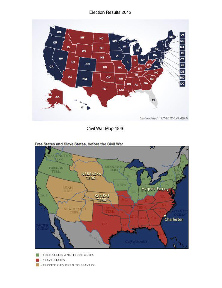
I found this image on Facebook. I’m not sure if it is valid. First of all, the Washington Territory wasn’t created until 1853, and yet this says the map is from 1846. And the Civil War itself didn’t start until 1861. So this is not a “Civil War Map” and it sure isn’t from 1846.
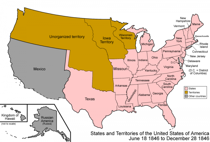
In fact, this is what the US looked like in 1846:

The question of which territories were open to slavery changed several times. In fact, in 1861, Kansas was admitted as a free state.
But regardless, it is interesting to see the lingering correlation between slavery and our current election results.


8 Comments
The 1858 map is at http://en.wikipedia.org/wiki/File:US_SlaveFree1858.gif and looks very much like the Free States and Slave States, Before the Civil war. I’m not sure it is legitimate, but there it is. Wow.
Yeah, I saw that image too, but it has even more problems.
http://www.learner.org/biographyofamerica/prog10/maps/
What are the problems with the Wiki map? The colors? :-). Then there is the map linked to by anonymous. I don’t know if they are correct. But they are consistent. No every on the Internet is true. Maybe this should not have been posted at all if there is so much doubt about it’s legitimacy.
Woohoo, the northern 1846 Texas panhandle voted to legalize pot!
Errors in both maps. Iowa became a state in 1846 (my ancestors first settled there in 1833). Texas a state in 1845, but in the shape it holds today – not the Republic of Texas shape. Oregon Country was gained from the British in 1846 and officially became a territory in 1848, then split in 1853 prior to Oregon becoming a state in 1859. CA, AZ, NM, NV, etc are properly shown as Mexico in the second map, all wrong in the first map. Wisconsin didn’t become a state until 1848. Yup, a lot of issues, but aren’t maps great?
I suspect it’s much closer to an 1860 map than an 1846 map.
Not to change the subject but this is an interesting comment about the election map looking at education and state by state results. http://i1308.photobucket.com/albums/s608/LegLamp/509bedacdc6e5.jpeg I did do a quick check of the referenced source and it does match the ‘Fox News’ list. I would like to see the full 50 state list that would be interesting.